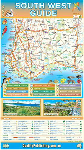
This map of the southern west of Western Australia covers from Lancelin in the north west to Kalgoorlie in the north east and down to the coast on one side. The other side of the map has a guide which shows all the main sights and attractions in the bigger towns throughout the area.
Road detail shows from major highways all the way down to unsealed roads, old tracks and 4WD only routes. Useful and interesting places are shown in abundance including various attractions, fuel stops, campsites, rest stops and fishing locations. Elevation tinting shows the topography. Also included are average monthly temperature and rainfall charts for many areas. The maps are surrounded with illustrations of native flora and fauna.